Ladakh Tourists' Circuits - Guide
Certain areas of Ladakh, which were formerly closed to foreigners on account of their sensitive strategic position or proximity to international borders, have recently been opened. Movement within these areas, however, is limited to a number of specifically designated circuits, and foreign visitors are allowed to go only in groups, accompanied by a recognised / registered tour operator. The maximum time allowed on a circuit is seven days. Permits must be taken from the Deputy Commissioner, Leh, but citizens of Pakistan, Bangladesh, Sri Lanka and Myanmar will be issued permit only with the prior approval of the Ministry of Home Affairs, Government of India, New Delhi. Foreign diplomats and members of the United Nations and other international organisations are required to apply for permits to the Ministry of External Affairs, Government of India, New Delhi.
Dah-Hanou (The Drok-pa Area Tour Circuit) - Down the Indus, between Khalatse and the Shayok-Indus confluence, live people, known as Drok-pa, who are Buddhists by faith, but racially and culturally distinct from the rest of the Ladakhis. Two of the five villages inhabited by them, Dah and Biama are now open to foreign tourists. The route follows the Indus river down from Khalatse, past the villages of Domkhar, Skurbuchan and Achinathang, along a fairly good road.
In the Indus gorge, where these villages are situated, the sun's heat is frequently intense which makes it possible to grow two crops every year in the fields. Fruits such as apricots, apples, walnuts and grapes are grown. Skurbuchan, Domkhar and Achina-thang are attractive villages, with an air of modest prosperity about them.
But the special interest of this region is its Drok-pa inhabitants. A minuscule community of perhaps no more than a couple of thousand, their features are pure Indo-Aryan, and they appear to have preserved their racial purity down the centuries. Their culture and religious practices are more akin to the ancient pre-Buddhist animist religion, known as Bon-chos, than to Buddhism as practised in the rest of Ladakh. One curious feature is their abhorrence of the cow or any of its products.
They have preserved their ancient traditions and way of life partly through the celebration of the triennial Bono-na festival, a celebration of the harvest, and partly through the songs and hymns.
One of these is a description of an ibex-hunt, for the ibex is especially sacred to them. Another recalls their migration from Gilgit, an event which must have occurred well before it came under the influence of Islam. Their language is said to be akin to that spoken in Gilgit, and by the immigrants from Gilgit settled in Drass.
Pangong Lake (Leh-Karu-Changla-Durbuk-Tangtse-Lukung-Spangmik Tour Circuit)
This route proceeds past the picturesque villages of Shey and Thikse, and turns into the side-valley of Chemrey and Sakti. The Ladakh range is crossed by the Chang-la (18,000 ft / 5,475 m) which is one of the easier passes remaining open for much of the year even in winter. Tangtse, just beyond the foot of the pass, with an ancient temple and a Tourist Bungalow, is a convenient halting point on this circuit.
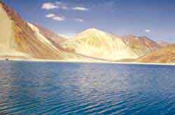
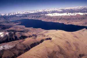
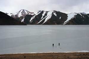 The main attraction of this circuit is the Pangong Lake, situated at an altitude of 14,000 ft (4,267m). It is a long narrow basin of inland drainage, hardly 6 to 7 kms at its widest point, and over 130 kms long, and bisected by the international border between India and China. Spangmik, the farthest point up to which foreigners are permitted, is about 7 kms along the southern shore from the head of the lake. It presents a spectacular view of the mountains of the Chang-chenmo range to the north, their reflections shimmering in the ever-changing blues and greens of the lake’s brackish waters. Above Spangmik are the glaciers and snow-capped peaks of the Pangong range. Spangmik and a scattering of other tiny villages along the lake's southern shore are the summer homes of a scanty population of Chang-pa, the nomadic herdsmen of Tibet and southeast Ladakh. The Pangong Chang-pa cultivate sparse crops of barley and peas in summer. It is in winter that they unfold their yak wool tents called rebo, and take the flocks of sheep and pashmina goats out to the distant pastures.
The Nubra Valley (Leh-Khardung-la-Khalsar-Tirit-Tegar-Sumur-Panamik Tour Circuit)
 The name Nubra is applied to the region comprising the valley of the river Nubra and that of the Shayok, both above and below their confluence, where they meander in many shifting channels over a broad sandy plain, before flowing off to the north-west to join the Indus in Baltistan. The Shayok and Nubra rivers drain the east and west sides of the Saser sub-range of Karakoram.
The route from Leh crosses over the Khardung-la, the highest motorable road in the world. The line of the road is different from that of the old pony-trail, longer and actually higher (18,300 ft 5,578 m). The view from the top is amazing. One can see all the way south over the Indus valley to the seemingly endless peaks and ridges of the Zanskar range, and north to the giants of the Saser massif. For several kilometres, on each side of the pass, the road, covered by deep snow in winter, is rough. For the rest of the way the road is good. At the confluence of the two rivers there is no dearth of water, but the sandy soil is not suitable for agriculture, which is confined to the alluvial fans where side streams drain into the main valley. The valley floor itself is covered with dense thickets of a thorny shrub, which the villagers use for fuel and for fencing, though there is now less need for this than there was in the days of the caravan trade with Central Asia when up to 10,000 horses a year are said to traverse the district. The villages are large and prosperous, and have thick plantations of willow and poplar. The altitude is a little less than that of Leh, varying between 10,000 ft (3,231 m) at Hundar, and 10,600 ft (3231 m) at Panamik. Summer temperatures vary between 15oC and 28oC.
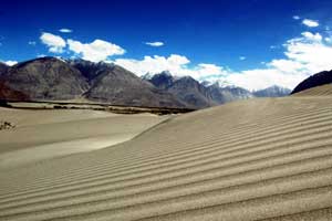
The main village is Deskit, which has a bazaar comprising of single line of shops, and a gompa situated on a rocky spur above the village with a commanding view. From Deskit, the route follows the course of the Shayok to Hundar, past an area of rolling sand dunes, with their contours liable to shift with every gale. There is a small population of the shaggy double-humped Bactrian camels, which in the old days were used as pack animals on the Central Asian trade route. During the past 50 years, they have been bred for transport purposes in Nubra. Today visitors to Nubra can use these animals for going on camel safaris.
The other circuit proceeds up the Nubra River, taking in the pretty villages of Tirit, Lukung, Tegar and Sumur. Nubra's other major monastery. Samsta-ling is situated on the mountainside just above Sumur. This was the route taken by the trade caravans. Panamik, the last village on this circuit, was at that time a busy centre, being the last major settlement before the caravans entered into the mountains of Karakoram and the Kun-Lu.
Here they halted for a few days to make final preparations for the journey across the mountains, or to recuperate on the way back. The Government maintained a granary to sell food grains for the men and even for the horses. But this arrangement was insufficient for the amount of the traffic, and the villagers made huge profits, selling grain and fodder and letting out their fodder-fields for the horses to graze in. Today, Panamik is a sleepy village, its inhabitants quietly going about their work in the fields. On the mountainside above the village, hot water bubbles out of the earth in thermal springs, reputed to have therapeutic qualities. Across the river, clinging to the mountains, are a few trees rooted among the rocks surrounding the tiny Ensa gompa.
Tso-Moriri Lake - The area traversed by the Manali-Leh road, and containing Tso-moriri and other lakes, is known as Rupshu. Here, the Zanskar range is transformed into bare rolling many-hued hills, divided by open high-altitude valleys scoured by dust devils. It is a landscape quite unlike any other in Ladakh or elsewhere in India. This area is now open for foreigners for visiting, along the two tour circuits.
 The first circuit follows the Manali road over the Taglang-la as far as Debring, a Changpa camping place. From here it strikes off eastward on a rough track across the basin of the twin lakes Startsapuk-Tso (fresh water) and the Tso-kar (salt water), over the Polokongka-la (about 16,500 ft/5,030 m) to Sumdo in the Puga Valley, near the site of old sulphur mines, then over a roller-coaster track to the head of the Tso-moriri, and on to Korzok viilage, a quarter of the way along the lake's 20-km length.
The alternative route, instead of leaving the Indus at Upshi, carries on up the river through the gorge between the Ladakh and Zanskar ranges, to the village of Chumathang, where there is a hot spring. At Mahe, about 17 kms further, the road crosses from the north to the south bank of the river, over a bridge, and then follows the Puga stream up to join the first circuit at Sumdo
Korzok, situated at 15,000 ft (4,572 m) with its dozen or so houses and its gompa, is the only permanent settlement in Rupshu, which is otherwise inhabited only by nomadic Chang-pa herdsmen. The Rupshu Chang-pa live in tents all the year round, moving according to an old established annual routine, between the pastures that exist wherever an occasional stream makes possible the growth of grass, which is said to be highly nutritious. The few barley-fields at Korzok are believed to be among the highest cultivation grounds in the world, although there is no guarantee that the crop will ripen every year.
Despite its barrenness Rupshu’s hills support a sparse population of wildlife, and the animal most likely to be spotted is the Kyang, the wild ass of the Ladakh and Tibetan plateaux. More plentiful are marmots (ubiquitous to mountain slopes all over Ladakh), hares, and an unusual tail-less rat. The lakes are breeding grounds for numerous species of birds. Chief among them is the bar-headed goose, found in great numbers on the Tso-moriri, the great crested grebe, the Brahmini duck and the bar-headed gull.